 |
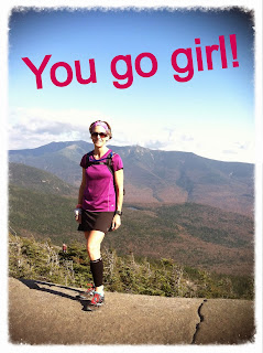
| Picture taken at the top of North Kinsman
|
Who is this girl? I have said it before but I never would I have imagined that I would be running mountains/trails for the fun of it! Well, I take that back. There was the time I ran away from home when I was around 3 years old. I grabbed my blueberry picking bucket, hiked up a big hill and headed out on the trail. Apparently I didn’t get very far because when my dad found me I was tumbled over, tangled in the wild blueberry bushes! My dad loves telling that story and now I get call him and share my true hiking/running adventures.
 |
| Beautiful colors all weekend long! |
 |
| At the trail head of Kinsman Trail |
I dedicated Columbus day weekend 2013 to me, myself, and I.
 |
| South Kinsman |
View from Bald Peak off of Kinsman Trail
Didn’t quite make it to Cannon but I made it to this un named 3,000 footer
The gorgeous trail as the sun was setting on the way down Kinsman
I decided to stay up there for the night and found this lovely campsite

It was “illegal” but it was also the middle of the government shut down and the campgrounds were closed and Ranger Rick wasn’t on duty to bust the rule breakers.
I started out on my 20ish mile journey from the trail head for North Twin mountain.
The morning fog was burning off but after I got above tree line this was the amazing view that I saw…
I headed to South twin then down to Galehead where this was the view…okay so there wasn’t a view!
Next up was Garfield…which provided another amazing view above the clouds. The view made up for the rugged trek and less than enjoyable terrain at times on the way over from Galehead.
I took Garfield trail back down and much to my surprise it was runnable! As I was heading down I passed a man and a group of young teenagers for a second time. They were surprised to see me running and one of the boys yelled “you go girl” and I thought to myself… Yeah, you go girl! I had a hug smile on my face the rest of the run down. Once I reached the access road I soon discovered that the map can prepare you for where to go but it cant prepare you for the elevation…The access road back to the trail that would eventually lead me to my car was all up hill and while I had intended to run it I had about 3-5 miles to go and my feet were less than thrilled. It was beautiful and made for a nice run/hike.

I have to admit, I wasn’t really sure where I was going, it all looked good on the map but what I was taking wasn’t really an established route but I made it…super proud of myself and super hungry. I wasn’t prepared with snacks/food for another day and managed to complete my 20 mile journey on a pack of shot blocks, peanut butter, 1 pack of vanilla gel and 2 rice cakes. BTW-vanilla gel tastes pretty good on a rice cake!
Little did I know that this adventure would kick start a new journey-hike all 48 of NH’s 4,000 footers!